Marker #72 Mystery Hill

22 10 2009

#72 Mystery Hill

Marker Text:

Four miles east on Route 111 is a privately owned complex of strange stone structures bearing similarities to early stone work found in western Europe. They suggest an ancient culture may have existed here more than 2,000 years ago. Sometimes called "America’s Stonehenge", these intriguing chambers hold a fascinating story and could be remnants of a pre-Viking or even Phoenician civilization.

This Marker was erected in 1970 in Salem, NH.  It’s on the east side of NH 28, about .7 mile south of its junction with NH 111, and 2 miles north of its junction with NH 97.

#72

Ok, where to start with this one.  History or Hoax? First, I listed this Marker next because the text says “pre-Viking or even Phonician!”   Did the people that petitioned for this Marker or the people that approved it even know who the Phoenicians were?  It’s almost Halloween, so lets put this Marker in the Category “Trick or Treat?”

Here’s a Satellite map of the Site.

Map picture

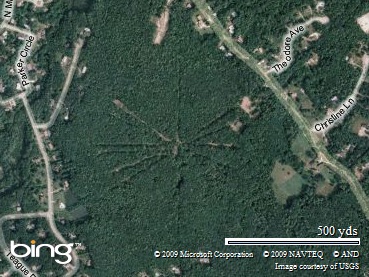
Pretty impressive.  From the eye in the sky, it looks like it could be something ancient.  But once we start digging into the History of the place, the questions start to build.  Here’s a topographic map (click the MyTopo button on the map) of Mystery Hill.  So we know it is indeed a Hill, and the image above shows stuff radiating out from the top of it.

Our Next stop, is the America’s Stonehenge web Site.  It’s privately owned, and charges admission to wander the grounds. If you can manage to Navigate the site, you’ll find the Gift Shop and Alpaca Farm.  The most interesting though, are the Brochure (PDF file)  which looks like every other tourist trap brochure in the state, and a Tour Guide Map (PDF file).

#72 zpic2

Is it a tourist trap, or is it it real? Boston University Archaeology Professor Curtis Runnels debunked the site back in 2002 in an Issue of the BU Bridge.

"No Bronze Age artifacts have been found there," he says. "In fact, no one has found a single artifact of European origin from that period anywhere in the New World."

Runnels discredits such questionable discoveries as America’s Stonehenge, the lost continent of Atlantis, and evidence of Noah’s Ark in his CAS undergraduate course Archaeological Mysteries: Pseudoscience and Fallacy in the Human Past.

Simply put, the Scientific evidence that the site is anything but Colonial in nature doesn’t exist.  They have run around and carbon dated things that may be old Native American campfires, or charcoal from old forest fires.  Quacks and kooks have claimed to find ancient writing on tablets, that no one but they could confirm.

Should any of this stop you from visiting?  I say, Hell No! Especially if you have kids, and want a quick getaway in Southern NH for cheap.  And since it’s Halloween, make sure you tell some scary stories while you’re in there!

Here are a few bonus links:

Back in 1997, a nice young lady by the Name of Donna Dube wrote a paper for her class on the place.  It’s a PDF, and has some great pictures.

Yankee Doodle Druids? A Discover magazine writer crosses over to the dark side.

A Preview of the Book, “America’s Stonehenge” on Google Books.

Photos of Mystery Hill from Google Picture Search.

Photos of Mystery Hill from Bing Pictures.


Marker #129 Indian Mortar Lot

22 10 2009

#129 Indian Mortar Lot

Marker Text:

The large mortar found here is in a boulder of glacial origin first hollowed out by water, then by many years of apparent use of Abnaki Indians, and later by the first settlers for grinding corn or maize which was made into cakes and baked over open fire. Also located in this historic lot is a boulder on which a shad is carved, perhaps by the red man to preserve a likeness of his favorite fish, which swam up the Winnipesaukee River when the shadbush blossomed. After the dams were built the fish disappeared.

Erected in 1979 in the town of Franklin, it’s located  at the northwest corner of Central Street (US 3/NH 11) and Dearborn Street.

#192

#129 zpic2

The stone in the center reads:

“This lot contains the ancient stone mortar  used by Abenaki Indians and pioneer settlers of Sanbornton.

Presented to Franklin Womans Club by descendants of James Clark, Esquire.

Native American Artifacts are all over New Hampshire.  Who were the tribes that lived here before the French and English settlers?  Here’s a chance to show off my mad Photoshop skills.

This map is a rough estimate of the tribes of the area.  Most of the Tribal boundaries follow the terrain.  Major Rivers, Mountain Ranges and the like were the borders, but always remained fluid.

tribe map

This map is based on those from Native-languages.org

As you can see, most of today’s New Hampshire, Vermont and Western Maine were populated by the Abenaki. Histories currently split them into two groups, Eastern and Western.  The Eastern Abenaki pretty much hung out East of the White Mountains and Maine.  The Western Abenaki lived in the Connecticut River valley west to Lake Champlain.

They were further identified into Bands that should sound familiar such as; Ossipee, Pemigewasset, Souhegan, Nashua, Penobscot, etc.

The first trade between Europeans and the Native Americans probably first occured as Samuel de Champlaine and Pierre DeMonts established Port Royal Nova Scotia about 1605.  The Fur Trade with the Penobscot (an Eastern Abenaki tribe) and Maliseet enriched those tribes with European goods, and created tensions with the Micmac across the bay in Nova Scotia.

Beginning about 1607 the Micmac and Maliseet were at war with the Penobscot, lasting about 8 years.  The fur trade continued with both sides, and the French Jesuits established a trading post and mission at what is now Bar Harbor, ME in 1613.  It didn’t last the year as Englishmen from Jamestown raided and destroyed it.

In 1615, the Micmac finally manadged to capture and kill Penobscot Chief Bashaba, ending the war.  The Micmac swept down the coast of Maine and New Hampshire.  That’s when they encountered Settlers diseases, and epidemics began sweeping the New England tribes.  There is no way to say exactly how many Native Americans died.

By 1616 the French had bailed out of most of their trading posts, save Port Royal and a small post at the mouth of today’s Penobscot River.  The French decided it was safer to head inland to the St. Laurence River Valley where the evil Englishmen couldn’t rough them up.

The first Abenaki contact with the English occured in 1607, at the mouth of the Kennebek River.  The Plymouth Company had attempted to established a colony there.

So there you have it.  A picture of some of the Native American tribes of New England, the impact of early settlers, and a nice introduction to the 1600s and Markers to come.  This site was a gold mine of Abenaki information, and is just one page of The First Nations Website.  You can read much more about the tribes of New England there, if you are so inclined.


Marker #149 Lochmere Archeological District

21 10 2009

#149 Lochmere Archialogical District

Marker Text:

The history of Lochmere, in the broadest sense, is the history of human use of the Winnipesaukee River. Navigable by canoe, the river served as a major transportation and communications route and, with falls and rapids, it has served as a source of food and water power. Thirteen archeological sites record nine millenia (sic –Mike) of prehistory by Native Americans, and eighteen sites relate directly to the domestic and industrial life of early mill owners and the early industrial period of the village of Lochmere.

Erected in 1984 and Located in Belmont, NH  The Lochmere Archeological District straddles the Winnipesaukee River (which is also the Tilton-Belmont town line) between Winnisquam Lake and Silver Lake. The marker is located about 1 mile east of US 3, on Silver Lake Road, at the Lochmere Dam.

#149

I chose this as the first marker to add, as it tries to pack a lot of history into one marker. Nine millennia of Native American history, transportation and communications, the Industrial Revolution, this marker defies placement in the timeline of New Hampshire History!  So I’ll get it out of the way first using the old “Hey, it talks about Native American Prehistory!”

Other than being stuffed between Tilton and Sanbornton along Rt 132, the Village of Lochmere itself has some small farms and homes as the road heads north.

*Update12/09 Updated Marker photo, and added photos below.

#149 zpic1 The river heading to Silver Lake.

#149 zpic2 Silver Lake, across the street from the marker