Marker Text:
Darby Field, a New Hampshire settler, accomplished this feat in 1642 from a southerly approach. Partly guided by Indians and with only primitive equipment at his disposal, he is thus alleged to be the originator of all Mount Washington ascensions.
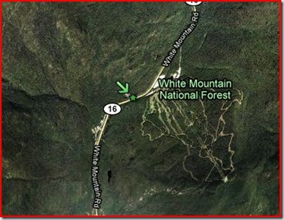
This Marker is located on the Northbound side of Rt. 16 about 1/3rd of a mile North of the Pinkham Notch AMC headquarters. It was erected in 1963.
Darby Field (1610-1649) was one of the early settlers of New Hampshire. We know that he was present to accompany Captain Neal on a first exploratory trip into the interior of New Hampshire in 1632.
Field probably arrived in New Hampshire in 1631. A bit of information from Sanborne (p307) indicates that he was soldier, sent to assist the exploration of New Hampshire:
"By the bark Warwick, we send you a factor to take care of the trade goods; also a soldier for discovery." "This soldier," says Mr. Potter, "was doubtless Darby Field, an Irishman who, with Captain Neal and Henry Jocelyn, discovered the White Mountains in 1632."
By 1635-38, he had settled in what is now Durham on the South side of the Oyster River (at the time, part of Exeter).
We have seen that the men of Dover collectively bought land of the Indians in 1635. Soon after that date they elected their governor, but what powers were conferred upon him can not now be told. They granted land before the year 1640 to several men at Oyster River, where Darby Field was in quiet possession of the "Point" earlier than 1639.
…On the other hand Darby Field, Ambrose Gibbons, Thomas Stevenson, William Williams and probably others then living on the south side of Oyster River, in what is now Durham …
His journey to the top of Mount Washington is not well documented The best description comes from the Journal of Governor John Wentworth, (Volume 2, p62-63). I’ll break the narrative down, and let’s see if we can’t follow Darby’s Trip.
“One Darby Field, an Irishman, living about Pascataquack, being accompanied with two Indians, went to the top of the white hill. He made his journey in 18 days.”
Field and two guides head off. Later, we will see he enlisted further help.
“His relation at his return was, that it was about one hundred miles from Saco, that after 40 miles travel he did, for the most part, ascend…”
Surprisingly accurate! A Google map search from Saco, ME to Mt. Washington gives 3 routes by car: 87, 91, and 115 miles. Various accounts say he “paddled up the Saco River”. Conway NH is 32 miles (by car) from the Mountain. From what comes next, we can guess where he might have been.
“for the most part, ascend, and within 12 miles of the top was neither tree nor grass, but low savins, which they went upon the top of sometimes, but a continual ascent upon rocks, on a ridge between two valleys filled with snow, out of which came two branches of Saco river, which met at the foot of the hill where was an Indian town of some 200 people.”
This part can be confusing, I’ll reverse this a bit. Let’s start with the Indian town. As best I can guess, this could be the confluence of the Saco and Ellis Rivers in Bartlett New Hampshire, near the Base of Mount Kearsarge. The Abenaki name of the Mountain, is “Pequawket.” This little fact leads to:
In 1642 Darby Field paddled up the Saco River in a canoe. This was over 300 years ago. He told about seeing thousands of acres at Pigwacket, an Indian town, This Indian town included all the land which is now Conway and Fryeburg, Maine.
It’s probably safe to say that the Indian town was in and around present day Mt. Washington Valley. Now lets check the first part of the last quote:
…and within 12 miles of the top was neither tree nor grass, but low savins, which they went upon the top of sometimes, but a continual ascent upon rocks,…
This would indicate that they began the climb, and cleared the tree line. However, we have to look at the next portion of the narrative:
Some of them accompanied him within 8 miles of the top, but durst go no further, telling him that no Indian ever dared to go higher, and that he would die if he went. So they staid there till his return, and his two Indians took courage by his example and went with him.
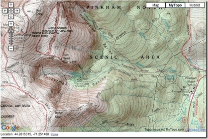
Some of the Indians from the town accompanied Field on his trek to the top, but at abut 8 miles, they would go no further. Field and his 2 guides from Exeter went on alone. This makes you wonder about the whole 12 mile comment 3 paragraphs above. There is no place in the Presidential Range that I know of that opens up above the tree line, and stays above, with 12 miles to go to the top of Mt. Washington. And you know me, I love maps So lets stick one in here! Any hikers that know this area, leave a comment correcting me please!
Click the map, and you can go to the Topographic map of the area, click the MyTopo button and explore!
The best route I can come up with probably started somewhere around Piknham Notch and went up the current Boott Spur trail, taking our intrepid band of explorers first to Boott Spur, which gives a clear view South to : “…which they went upon the top of sometimes, but a continual ascent upon rocks, on a ridge between two valleys filled with snow, out of which came two branches of Saco river, which met at the foot of the hill where was an Indian town…” it would be easily visible on a clear day. That’s my story, and I’m stickin’ to it.
“They went divers times through the thick clouds for a good space, and within 4 miles of the top they had no clouds, but very cold. By the way, among the rocks, there were two ponds, one a blackish water and the other reddish. The top of all was plain about 60 feet square.”
This almost sounds like they went by the Lakes of the Clouds, but it could have been some puddles. Up through the clouds with dropping temperatures they finally reach the top where Wentworth describes what Field saw.
On the north side there was such a precipice, as they could scarce discern to the bottom [Great Gulf –Mike]. They had neither cloud nor wind on the top, and moderate heat.
All the country about him seemed a level, except here and there a hill rising above the rest, but far beneath them [probably the Presidential Range]. He saw to the north a great water which he judged to be about 100 miles broad, but could see no land beyond it.
The sea by Saco seemed as if it had been within 20 miles. He saw also a sea to the eastward, which he judged to be the gulf of Canada: he saw some great waters in parts to the westward, which he judged to be the great lake which Canada river comes out of [Probably Lake Champlain] .
He found there much muscovy glass,[Mica Formations] they could rive out pieces of 40 feet long and 7 or 8 broad.
More than 350 years ago, before the distances Field was seeing had hardly been explored, it’s to be expected that he would base his observations on the few watery landmarks that were known at the time. All in all, it was a wonderful observation.
When he came back to the Indians, he found them drying themselves by the fire, for they had a great tempest of wind and rain.
Welcome to New England. Don’t like the weather? Wait around a bit, it’ll change.
About a month after he went again with five or six in his company, then they had some wind on the top, and some clouds above them which hid the sun. They brought some stones which they supposed had been diamonds, but they were most crystal. See after, another relation more true and exact.
And here the Narrative ends. Think for a moment how the Wilderness must have seemed 350 years ago to the early settlers and Darby Field. No towns beyond the coast, no roads or settlements. Just forest and Native American tribes. It must have been quite a trip.
Finally, my video of Darby Field’s expedition, using the Google Earth Trip Function. I hope you enjoy it!
This was a great marker to research. Bonus point to anyone that can identify the Music in the above Video. Leave a comment!


