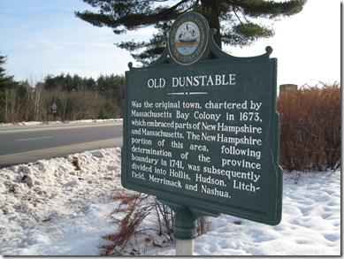
Marker text:
Was the original town, chartered by Massachusetts Bay Colony in 1673, which embraced parts of New Hampshire and Massachusetts. The New Hampshire portion of this area, following the determination of the province boundary in 1741, was subsequently divided into Hollis, Hudson, Litchfield, Merrimack, and Nashua.
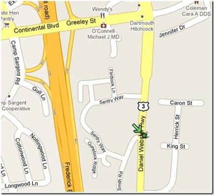
This marker was originally erected in 1965 south of the old Merrimack Toll plaza on the Everett turnpike. The toll plaza was replaced in the early 1990s by the Bedford toll, and the marker moved to its current location, on Rt. 3 south, about 1/4 mile south of exit 11.
The early New Hampshire and Massachusetts settlers increased dramatically in the mid 1600s. The major seacoast settlements were overcrowding and more people petitioned for land. As a result, settlements began to push inland, and a perfect location for farming and milling was the Merrimack valley and its associated tributaries.
 Merrimack River Basin map, by Karl Musser
But before we learn more about Old Dunstable, how did the Merrimack Valley become such an attractive settlement area in the first  place? Let’s go back a few million years and find out. The New Hampshire we love today at one time sat over the “New England Hot Spot” as the North American Plate moved west about 100 million years ago. The result was a whole bunch of White Mountains, and some volcanoes such as the long dormant ring dike volcano, we call The Ossipee Mountains (left, click for map).
And then the glaciers came. From about 70,000 years ago, to as early as 10,000 years ago the earth repeatedly warmed and cooled, as it continues to do today. The last glaciers covered all of New Hampshire, grinding and scouring on their way down, then leaving rivers lakes and the Merrimack Valley behind on the way back. The good news is that the glaciers receded. The bad news is that we’re overdue to cool again. Just saying.
Back to our settlers. As early as 1655 land grants were being handed out in the valley. At the time, a large tract of land would be assigned, and the person receiving the grant needed to recruit families to work and settle the area. This continued to 1673. That year, 26 of the proprietors of the land – or potential proprietors – petitioned the General Assembly of Massachusetts that their farms (over 14,000 acres by now) be combined into a plantation for the common good. The assembly agreed, and “Dunstable” was founded.
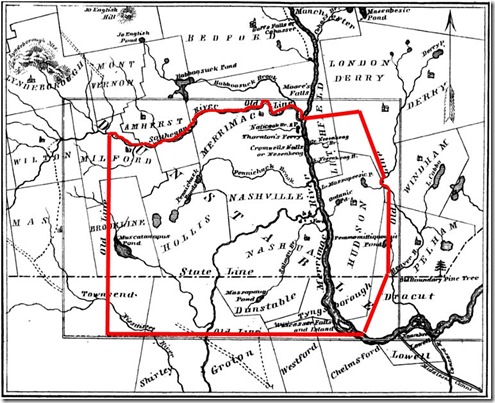 Map from The History of Old Dunstable page 14. Charles Fox – 1846
I’ve highlighted the boundaries in red of the new town. The town listed as Nashville was eventually incorporated into Nashua, and today the Nashville Historic District is located just north of downtown Nashua, on Concord St.
It’s a large piece of land – more than 200 square miles – and the inhabitants needed the security of a community vs. scattered farms. In general their relations with the local Abenaki were cordial, many of them having become Christians. And they were united to keep the aggressive Mohawk tribes from New York at bay. As more settlers came into the area though, they began pushing the local tribes further away, assigning the Abenaki lands of their own.
By 1675 and the outbreak of King Philips war and his intent to “exterminate the English”, few Garrison houses had been built. The most settled area was in and around todays Nashua, especially where the Nashua River joins the Merrimack. The local Abenaki, having no desire to join the fight against the English went north. Most all of the residents of Dunstable decided to leave for the coast. They were few, isolated and 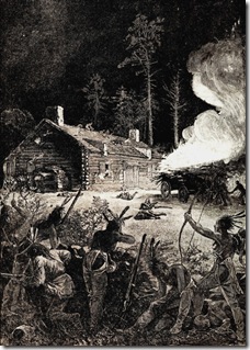 vulnerable to attack on the frontier.
The settlers petitioned the colony for security. The main Garrison at Dunstable was reinforced. King Philip and the better part of his army was defeated in August the following year. Many more fortifications were added after the war. The settlers returned to clear the land and make their homes, and the first meeting house was erected by 1678 near the Salmon Brook settlement in Nashua.
When King Williams War came to the new world in 1689 the residents of Dunstable only numbered between 30 and 40 families and would dwindle to about 25 families by the end of the war in 1697. Constantly worried about imminent attacks, many families left.
Things remained peaceful for 6 years until the outbreak of Queen Anne’s War in 1703. And once again Dunstable was exposed. The French were up to their old tricks inciting the Indians against the English. The inhabitants of Dunstable moved into the protection of the Garrison houses. More fortifications were erected and men and money sent from the General Assembly. Things would not improve much, there were simply too few people and men at arms to protect the whole frontier.
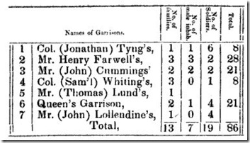 Of the 7 Garrisons in Dunstable in 1711(2 years before the end of Queen Annes War), Fox shows us a tally from the Massachusetts military records. The small columns read: “No. of families”, “No. of male inhab.”, “No. of Soldiers.”, “Total”.
It’s a pretty sad state of affairs. 19 soldiers and 7 men able to fight. The other 60 women and children. The war ended in 1713 but the worry would linger even as the settlements began to grow.
Now the settlement would accelerate. The first in Hudson was in 1710, Nutfield (now Londonderry) in 1719, Brettons Farm (Litchfield) and Chester in 1720, and Merrimack and Pelham in 1722. The increase in people meant security in numbers and the Dunstable settlements in the Valley grew quickly. As the settlements grew larger they petitioned the General Assembly to incorporate as towns. The names and boundaries would be defined throughout the 1730s. Merrimac, Nottingham-West (now Hudson), Litchfield, Hollis, Townsend, Nashua, Tyngsborough, Nashville (now part of Nashua).
Finally in 1741 the long dispute between Massachusetts and New Hampshire over the boundaries was settled and “Old Dunstable” found itself sliced nearly in half. Not all of the newly minted New Hampshire residents were pleased, but there was not much they could do. They had invested in land, mills, farms and homes. If they could see us now, I’m sure they would choose New Hampshire.
Postscript: This Marker is posted out of order. The state marker web site (where I swiped my database) has numbers transposed, listing the charter as 1763 instead of 1673.
Finding this marker was a true pain. They had to move it someplace! If you are coming up Rt. 3 from Nashua the back side of the marker is blank, and I don’t remember seeing any “Historic Marker Ahead” signs in either direction. Just look for the Citizens Bank.
I exclusively used James Fox 1846 volume History of Old Dunstable for this article. Of course, any errors are mine.
