Marker #58 Scotch-Irish Settlement – and Tartan!

19 01 2010

#58 Scotch-Irish Settlement

Marker Text:

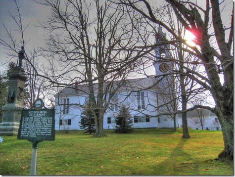
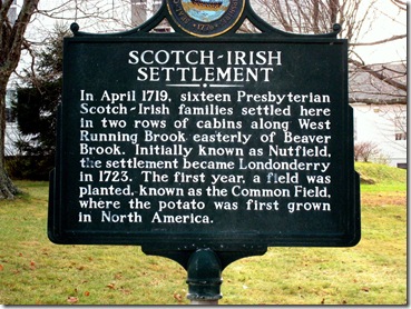
In April 1719, sixteen Presbyterian Scotch-Irish families settled here in two rows of cabins along West Running Brook easterly of Beaver Brook. Initially known as Nutfield, the settlement became Londonderry in 1723. The first year, a field was planted, known as the Common Field, where the potato was first grown in North America.

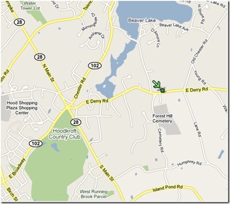
Located about a mile east of the Derry rotary on East Derry Rd in front of the East Derry Church and site of the first meetinghouse. Marker erected in 1969.

#58


The Scotch-Irish – also known as the Ulster-Scots – have  a pretty interesting history.  Back in the days of King James I and through the 1600s, there were settlers sent from Scotland to Catholic Ireland.  One of the first was in what came to be known as Ulster County.  The major town was … Londonderry!

Of course the native Catholics weren’t to happy about having land given to these immigrating Presbyterian Scotsmen. It didn’t take long before hostilities broke out. 

By 1641 The Irish Rebellion was in full swing.  This was pretty much the start of the centuries long strife between the Protestants and Catholics in Ireland.  We don’t need to go through it all here.  Lets just follow the Scotch-Irish that came to New Hampshire.

As previously noted, the Scotch-Irish were Presbyterians.  They had splintered away from the official English church.  In 1688 the ascension of William to the English throne brought relative peace to Ireland.  The Scotch-Irish were allowed to practice their religion, but were required to pay the church of England 10% of everything they produced.  They land they lived on and worked was only leased to them by the crown – they could be evicted at any time.

Edward Parker, in his 1851 “History of Londonderry” quotes an earlier historian commenting on the feelings in Northern Ireland at the time between the Protestants and the Catholics:

"On the same soil dwelt two populations, locally intermixed, morally and politically sundered. The difference of religion was by no means the only difference, and was perhaps not even the chief difference, which existed between them. They sprang from different stocks. They spoke different languages. They had different national characters, as strongly opposed as any two national characters in Europe. They were in widely different stages of civilization. There could, therefore, be little sympathy between them ; and centuries of calamities and wrongs had generated a strong antipathy. The relation in which the minority stood to the majority, resembled the relation in which the followers of William the Conqueror stood to the Saxon churls, or the relation in which the followers of Cortez stood to the Indians of Mexico."

So there they were.  No real land ownership, taxed to support a church they didn’t believe in and surrounded by animosity from both the Irish Catholics and church of England.  And they had heard things.  Good things about new freedoms across the Atlantic.  It didn’t take long for them to realize leaving for the new world might not be such a bad idea.

Four Presbyterian clergymen gathered all the interested families from their churches. 217 signed the request that was sent to Boston in the hands of Reverend Boyd.  The colony said “sure, come on over!” and they did.  They arrived in Boston in August of 1718.

In the fall of that year a gentleman named MacGregor took 16 of these families to Casco Bay to find a place to settle, but arrived late in the fall.  They spent a miserable winter aboard ship, sick and hungry, iced into the bay.  Boston sent enough food to see them to the spring.

In the spring they explored the lands around Casco Bay but couldn’t find anything to their liking.  So they struck west into the Merrimack valley, arriving at the settlement in Haverhill, MA.  Once there they began asking about land that could be settled and were told of an area called Nutfield, about 15 miles northwest.  The men went to explore the new area and fell in love. 

#58 mid_plus_dark_tonemapped November 2009

They communicated the selection of the land to Boston – making their claim – and proceeded to build some crude huts before returning to gather up their families and few possessions for the trip to their new home.   As the marker notes, 5 years later they renamed the town after their old home in Ireland, Londonderry.

Now to important stuff.  Potatoes!  That’s quite a claim on the marker: “The first year, a field was planted, known as the Common Field, where the potato was first grown in North America.”  Could it be true?  This calls for some intense googling.

It seems that a few people brought some potatoes in the 1600s, but no one really established a potato plantation.  All of the most reliable Potato Historians do indeed place the first legitimate Potato farms in Londonderry, 1719.  Take that Maine!

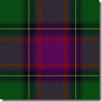
Special bonus for all my Crafty readers, the Official State of New Hampshire Tartan!

Yes we do have one, approved by the state legislature in 1995 to commemorate the 20th anniversary of the New Hampshire Highland Games.

 Tartan

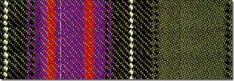
Here is the Sett for the Tartan:

green 56, black 2, green 2, black 12, white 2, black 12, purple 2, black 2, purple 8, red 6, purple 28

tartan2The colors represent:

Green represents our forests, Black the granite of our mountains, White is the snow, Purple our state flower the Lilac and bird the purple finch.  Red represents all our state Heroes.

I’ll let some of our weavers explain how a list of colored string gets turned into tartan.  Looms scare me.


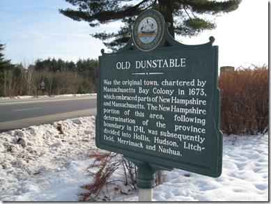
Marker #29 Old Dunstable

15 12 2009

#29 Old Dunstable 2

Marker text:

Was the original town, chartered by Massachusetts Bay Colony in 1673, which embraced parts of New Hampshire and Massachusetts. The New Hampshire portion of this area, following the determination of the province boundary in 1741, was subsequently divided into Hollis, Hudson, Litchfield, Merrimack, and Nashua.

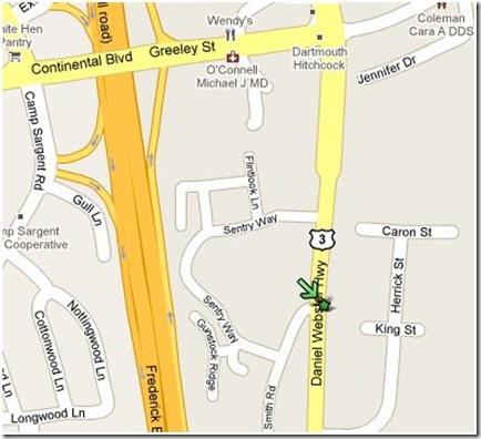
This marker was originally erected in 1965 south of the old Merrimack Toll plaza on the Everett turnpike.  The toll plaza was replaced in the early 1990s by the Bedford toll, and the marker moved to its current location, on Rt. 3 south, about 1/4 mile south of exit 11.

#29

The early New Hampshire and Massachusetts settlers increased dramatically in the mid 1600s.  The major seacoast settlements were overcrowding and more people petitioned for land.  As a result, settlements began to push inland, and a perfect location for farming and milling was the Merrimack valley and its associated tributaries.

 Merrimack River Basin map, by Karl Musser

But before we learn more about Old Dunstable, how did the Merrimack Valley become such an attractive settlement area in the first ossipee place?  Let’s go back a few million years and find out.  The New Hampshire we love today at one time sat over the “New England Hot Spot” as the North American Plate moved west about 100 million years ago.  The result was a whole bunch of White Mountains, and some volcanoes such as the long dormant ring dike volcano, we call The Ossipee Mountains (left, click for map).

And then the glaciers came.  From about 70,000 years ago, to as early as 10,000 years ago the earth repeatedly warmed and cooled, as it continues to do today.  The last glaciers covered all of New Hampshire, grinding and scouring on their way down, then leaving rivers lakes and the Merrimack Valley behind on the way back.  The good news is that the glaciers receded.  The bad news is that we’re overdue to cool again.  Just saying.

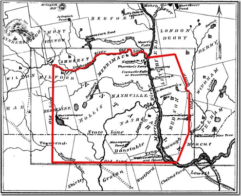
Back to our settlers.  As early as 1655 land grants were being handed out in the valley.  At the time, a large tract of land would be assigned, and the person receiving the grant needed to recruit families to work and settle the area.  This continued to 1673.  That year, 26 of the proprietors of the land – or potential proprietors – petitioned the General Assembly of Massachusetts that their farms (over 14,000 acres by now) be combined into a plantation for the common good.  The assembly agreed, and “Dunstable” was founded.

dunstablehilight Map from The History of Old Dunstable page 14.  Charles Fox – 1846

I’ve highlighted the boundaries in red of the new town.  The town listed as Nashville was eventually incorporated into Nashua, and today the Nashville Historic District is located just north of downtown Nashua, on Concord St.

It’s a large piece of land – more than 200 square miles – and the inhabitants needed the security of a community vs. scattered farms.  In general their relations with the local Abenaki were cordial, many of them having become Christians.  And they were united to keep the aggressive Mohawk tribes from New York at bay.  As more settlers came into the area though, they began pushing the local tribes further away, assigning the Abenaki lands of their own.

By 1675 and the outbreak of King Philips war and his intent to “exterminate the  English”, few Garrison houses had been built.  The most settled area was in and around todays Nashua, especially where the Nashua River joins the Merrimack.  The local Abenaki, having no desire to join the fight against the English went north.  Most all of the residents of Dunstable decided to leave for the coast.  They were few, isolated and indian-attack vulnerable to attack on the frontier.

The settlers petitioned the colony for security.  The main Garrison at Dunstable was reinforced.  King Philip and the better part of his army was defeated in August the following year.  Many more fortifications were added after the war.  The settlers returned to clear the land and make their homes, and the first meeting house was erected by 1678 near the Salmon Brook settlement in Nashua.

When King Williams War came to the new world in 1689 the residents of Dunstable only numbered between 30 and 40 families and would dwindle to about 25 families by the end of the war in 1697.  Constantly worried about imminent attacks, many families left.

Things remained peaceful for 6 years until the outbreak of Queen Anne’s War in 1703.  And once again Dunstable was exposed.  The French were up to their old tricks inciting the Indians against the English.  The inhabitants of Dunstable moved into the protection of the Garrison houses.  More fortifications were erected and men and money sent from the General Assembly.  Things would not improve much, there were simply too few people and men at arms to protect the whole frontier.

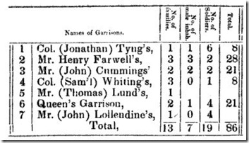
countOf the 7 Garrisons in Dunstable in 1711(2 years before the end of Queen Annes War), Fox shows us a tally from the Massachusetts military records.  The small columns read: “No. of families”, “No. of male inhab.”, “No. of Soldiers.”, “Total”.

It’s a pretty sad state of affairs.  19 soldiers and 7 men able to fight.  The other 60 women and children.  The war ended in 1713 but the worry would linger even as the settlements began to grow.

Now the settlement would accelerate.  The first in Hudson was in 1710, Nutfield (now Londonderry) in 1719, Brettons Farm (Litchfield) and Chester in 1720, and Merrimack and Pelham in 1722.  The increase in people meant security in numbers and the Dunstable settlements in the Valley grew quickly. As the settlements grew larger they petitioned the General Assembly to incorporate as towns.  The names and boundaries would be defined throughout the 1730s.  Merrimac, Nottingham-West (now Hudson), Litchfield, Hollis, Townsend, Nashua, Tyngsborough, Nashville (now part of Nashua).

Finally in 1741 the long dispute between Massachusetts and New Hampshire over the boundaries was settled  and “Old Dunstable” found itself sliced nearly in half.  Not all of the newly minted New Hampshire residents were pleased, but there was not much they could do.  They had invested in land, mills, farms and homes.  If they could see us now, I’m sure they would choose New Hampshire.

Postscript:  This Marker is posted out of order.  The state marker web site (where I swiped my database) has numbers transposed, listing the charter as 1763 instead of 1673.

Finding this marker was a true pain.  They had to move it someplace!  If you are coming up Rt. 3 from Nashua the back side of the marker is blank, and I don’t remember seeing any “Historic Marker Ahead” signs in either direction.  Just look for the Citizens Bank. 

I exclusively used James Fox 1846 volume History of Old Dunstable for this article.  Of course, any errors are mine.


Marker #49 Hannah Dustin

10 12 2009

#49 Hannah Dustin

Marker Text:

Famous symbol of frontier heroism. A victim of an Indian raid in 1697, on Haverhill, Massachusetts, whence she had been taken to a camp site on the nearby island in the river. After killing and later scalping ten Indians, she and two other captives, Mary Neff and Samuel Lennardson, escaped down the river to safety.

This Marker is at the “Hannah Dustin” Park n’ Ride on Rt 4, a mile west of I93 off exit 17.  It was erected in 1967.

#49

The story of Hannah Dustin has been told many times in History books and through poetry and writings of many notable authors.  The first appeared in Cotton Mathers history of the New England colonies.

Mather

Mather had personally interviewed Dustin after her escape from captivity, and many of the other re-tellings of the tale are based on his account.

Thomas and Hannah Dustin lived in the then small frontier town of Haverhill, MA.  On Wednesday March 15th 1697 Thomas was about doing work while Hannah lay in bed recovering from the birth of her eighth child about a week earlier, with Mary Neff taking care of her.

The day was interrupted by the sudden war cries of an Indian raiding party.  Thomas grabbed his musket and ran for the house as the raid began. In her weakened condition, Hannah was in no shape to run, and begged Thomas to save the children.  The infant would have to stay with her and Mary.

Thomas gathered the children and told them to run for the Garrison house while he held off the Indians should they pursue.  And they did.  Accounts vary about the childrens escape and Thomas’ deeds, but all agree that Thomas held off the Indians with his rifle, killing at least one attacker and getting the children to safety.  His deeds that day would eventually be immortalized in a poem by Sarah Hale (who has her own marker) called “The Father’s Choice” which begins:

Now fly as flies the rushing wind!

Urge, urge thy rushing steed!

The savage yell is fierce behind;

And Life is on thy speed.

Meanwhile, Hannah was forced from her bed and taken captive along with her nurse and infant.  After gathering all their captives together the raiding party headed back to their canoes on the bank of the Merrimack.  On the way there, Hannahs infant son was murdered by having his head smashed against an apple tree.  On the trip to the river and up the Merrimack many that were too old, slow or sick would be killed and left behind as well.

It’s difficult to imagine what Hannah Dustin was feeling.  Rage?  Sorrow?  Many have speculated in the various versions of her story, including Nathaniel Hawthorne;

hawthorne2

The raiding party and their captives covered 15 miles the first day and all struggled tocanoe keep up or die.  They travelled for 15 days all told, and as was the custom of the Indians at the time the captives were split between the participating Tribes.

Hannah and Mary Neff were given together to a band that made camp on what is today Dustin Island.  Along the way the Indians made their plans clear. After resting a few days they would travel North to Canada where the captives would be run through a gauntlet of the tribe, suffering greatly.  Afterward, if they survived, they would be sold in slavery to the French.  Not a very promising future.

#49 zpic3

At the island on their arrival were the families of the raiders, and a young man named Samuel Lennardson that had been captive for over a year and spoke the Indian language well. Hannah would concoct her plan.  She asked Samuel how the Indians killed with a single blow, and how they scalped people.  Not knowing, Samuel asked one of the raiders.  They viewed the women and boy as no threat so the Indian told him.

As the camp fire died away and the night deepened Hannah informed Mary and Samuel of her intentions.  She planned to kill the Indians and escape. 

camp Late in the night as the Indians slept the three captives took up Tomahawks and killed all the Indians but two.  One woman escaped into the forest, and a young boy was spared.  Ten lay dead.

It was time to make their escape.  On reaching the canoes, they scuttled all but one.  Mary and Samuel were anxious to leave, but Hannah had one more grisly task in mind.  She asked them to wait and disappeared into the woods back toward the camp.

She returned a short time later with ten scalps. Again, it’s hard to determine her emotions but there is no doubt revenge for the murder of her child certainly played a part.  They pushed off into the river and began the long trek back down the Merrimack to Haverhill.

Returning to Haverhill she learned that Thomas, for his brave deeds had been requested to build and run a new Garrison in town.  It’s at 665 Hilldale Ave in Haverhill, and is open occasionally as a museum. (click the picture for a web page).

Today the Monument erected to Hannah Dustin on June 17, 1874 still stands on the Island that bears her name.

#49 zpic4 Hannah Dustin Monument, December, 2009.

The complete proceedings of the unveiling of the monument is contained in the rear of the book “The Heroism of Hannah Dustin” By Col. Robert Caverly for those that may be interested.  Caverly was instrumental in acquiring the land, raising the funds and having the statue sculpted.  He delivered a historical address at the unveiling, part of which was;

To adorn and enliven such a history there are no better examples in all the events of the world, than are to be found in the lives and characters of the old New-England mothers. Try them; measure their faith, if you please, as in the days of dearth and disappointment. Measure them in the midst of conflagrations, war, and blood, or in the tranquil years of peace and plenty; or try them in the appalling perils of an Indian raid upon their houses, their little ones, and their lives. Stern in integrity, strong for endurance, firm in truth, and fervent in valor forever, they never faltered.

From the Parking area where the Marker is located, there’s a walking path down to the island and monument for those that may be in the area contemplating a visit.

#49 zpic12

#49 zpic2


#49 zpic10

daughters

Daughters of the American Revolution Magazine Volume 15 1899